.webp)
I recently attended an ESRI Conference in Auckland as a guest of Eagle Technology.
I'm going to admit right now that I perceived GIS (geographic information systems) as old school systems bought by local government to plan the sewers.
Boy was I wrong.
So what is GIS?
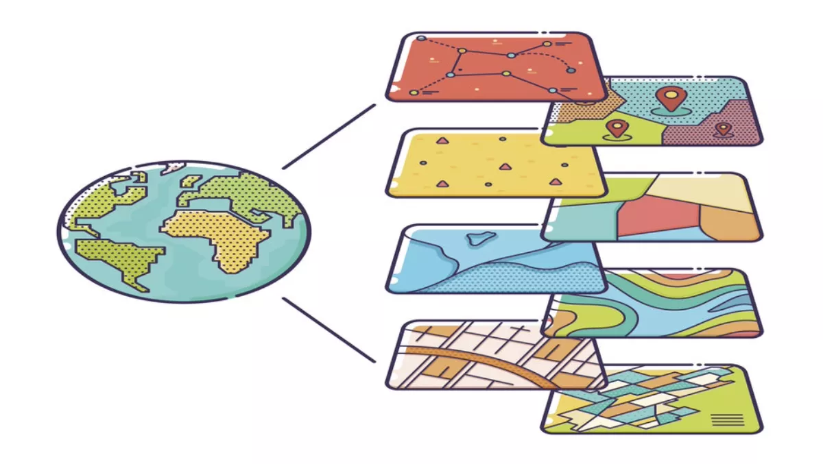
Traditionally GIS was used as a enterprise computer system and a framework of record. Meaning that organisations would use it to map out where forestry trees, telecommunications poles, assets in the field and so on were located.
ESRI is the leading GIS solution and is represented in New Zealand by Eagle Technology. ESRI's core solution has a number of basic maps, or what they call datasets, included. Then there's a marketplace available with thousands of additional datasets like traffic, imagery and temperature.
The organisation using GIS can overlay these datasets and their own data over the top of the basic maps.
Environmental use
One of the organisations I discovered at the event was NZ GIS in Conservation, a not-for-profit organisation that uses GIS software to make ecological conservation efforts more efficient.
There are a large number of projects, sanctuaries and local iwi using their systems to map projects, dispatch volunteers efficiently, save time and deliver better outcomes for the environment.
Projects include Enhancing the Halo, a Wellington conservation initiative that aims to create a safe haven for native wildlife in backyards. Local homes can become a ‘Halo Household', and join the cause, assisting with trapping efforts in their backyards - all of which is mapped using GIS.
The Department of Conservation utilised GIS to show the distribution of exotic pests across the country, revealing they can be found over 96.5% of land areas in New Zealand.
Fleets and vehicles
GIS can be used by organisations to more efficiently manage their fleets, understand traffic patterns, plan optimal positions for electric car chargers and where electricity companies will need power at certain times – for example, if people are leaving cities on weekends with their electric cars.
It can also help with complex routing for trucks in real-time. For companies like UPS, where a minute is a million dollars, GIS can provide operational efficiency.
Driverless cars will need enhanced Road Network data from organisations like ESRI and Here, a Nokia company.
Demographic planning
A company planning where to put a shopping mall can use GIS to retrieve relevant information, such as figures on motorways which make it faster to get to another mall for local residents.
All of this can be taken into account with new layers of data like traffic flow, population size and other demographics for the area.
As an example, KFC previously used to locate stores in areas of high density for a certain demographic. Now, the fast-food chain uses GIS to decide what items should be on the menu. This is based on income, ethnicity and consumer profiling.
Based upon the layering of other information, for example weather, over the top of those store location maps, more staff or more ice cream can be arranged for a particular store. This information can be fed into digital signage inside and outside the store, in addition to being utilised for long term stock level planning.
Monitoring
Airbus Defence and Space offers daily, weekly and monthly site monitoring from satellites that can automatically feed into GIS systems for business or emergency services.
With the information available down to 50cm resolution, it is in use by a range of organisations, from disaster relief, search and rescue and environment agencies, to construction and oil and gas companies worldwide.
The New Zealand Government pays Airbus for 1.5 metre resolution data to be provided free to the New Zealand public and businesses. This is part of a wider initiative by the government - and Bill English as it's most ardent supporter - around open access to government data. A leader in this area is Wellington City Council with almost all of their data already publicly available.
Agriculture
GIS also has a role to play in agriculture, as to maximise profits and optimise your yield, it's vital that you dedicate the right crops and equipment to where they can flourish.
With GIS, you can access high-resolution imagery to observe your fields with real-time data feeds to understand how to make the most of your resources at any given time.
It can effectively allow you to remove the guesswork from your production and manage your land more efficiently.
Cloud
As with so many other areas of technology, GIS have moved into the cloud.
Eagle Technology offers ArcGIS for Server on Amazon's Web Services, offering the flexibility, scalability and efficiency that modern businesses require.
The move to cloud also makes it easier for web developers to incorporate GIS into web apps and websites.
Local developers like Isovist.co.nz, based in Wellington – who are experts at making mapping technologies intuitive and simple in web apps and development – leverage the ESRI framework.
In summary
As you can see, a serious eco-system has developed around the core ESRI products and datasets, which aren't just of benefit to business services but society as a whole.
I take back my old fashioned view of GIS; it's changing significantly, from a system of record for assets to a system of engagement for business and government with the new mobile-centric world.
And what's more, we've barely scratched the surface of ways to use GIS to make the world a better and more efficient place.